A united African continent has been the vision and drive for a couple of great African leaders in the past. Dr. Kwame Nkrumah has in the past aimed for a united African front that could benefit immensely from each other in oneness, drawing inspiration from advanced science and technology to engage collaborations that would foster harmony, boost the economies, and consequently eradicate poverty.
Growing cooperation in continental commerce, as well as flexible border and port agreements, have rendered the need for a network that would facilitate access to inaccessible areas whiles optimizing travel time. According to the United Nations Economic Commission for Africa, UNECA, the African continent has enjoyed a 52% trade boost to about US $35 billion in five years through the easing of stringent border controls and a drop in the cost of tolls, and duties. With the introduction of the most comprehensive global market in the Continental Free Trade Area (CFTA) across the African Union, the continent is adamant in its optimism of a positive turnaround.
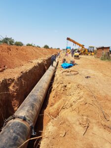
The apparent hike in commerce and economic operations have propelled a worthwhile investment in road and rail network as well as other imperative infrastructures to enhance continental cooperation. Although it is uncompleted, the ambitious Trans-African Highway has been identified as a tenable solution amid others with substantial capacity to drive this cause.
The massive intercontinental infrastructure has been flirted around for over half a century with hopes to someday complete. Conceived in the year 1971 by the United Nations Economic Commission for Africa (UNECA), it was visualized to stretch out across the African continent-spanning collective 60,000-kilometer road networks, segmented into nine major corridors/highways. The Trans-African Highway project envelops the construction and management of a series of roads and highways across the African continent. Sometimes referred to as the Trans-African Corridors, the infrastructure is a 56,683 km lengthy corridor, that serves 9 links and is being fashioned by the United Nations Economic Commission for Africa (UNECA), the African Development Bank (ADB), and the African Union, in an alliance with regional international communities.
The 9 highway links have been sorted into a group of six major East-West corridors and three North-South routes, although a fourth link North-South of the continent, has been forged by boundaries of two Eastern West Courses.
Our article will look into all the 9 highway schemes, the progress so far with each project and the countries being connected.
Trans-African Highway 1, Cairo–Dakar Highway, 8,636 km (TAH 1).
The Cairo- Dakar Highway links the Trans-African Highway 7 (also known as the Dakar–Lagos Highway) to create an additional North-South pathway around the continent’s western outline. It travels along the Mediterranean coast of North Africa threading from Dakar to Algiers through Rabat, and then across Tunis, Tripoli, and finally Cairo. The 8,636 km coastal trip is currently sufficiently complete and operational even with the closed Algerian and Moroccan borders. A patchy few kilometers on the border between Morocco’s Western Sahara and Mauritania only have desert tracks, even though the Nouadhibou-Nouakchott road had been tarred way back in 2005.
Trans-African Highway 2, Algiers–Lagos Highway, 4,504 km(TAH 2).
The Trans-African Highway 2 traverses across from Algiers, running through the Tamanrasset Province in southern all the way to Lagos down south. Preconceived beyond the mid-sixties (1962), it wasn’t till the 1970s did construction of segments of the Sahara began, rendering the Algiers–Lagos corridor one of the oldest on the continent. The Trans- Sahara highway is also one of the most complete highway networks of the project with only about 200 km of untarred desert track left, although border control is uncompromising on its use. The central region proves a challenge, however, and implores strict measures and vehicle specifications to enhance safety against a harsh desert environment and climate.
Trans-African Highway 3 (TAH 3), Tripoli–Windhoek – (Cape Town) Highway, 10,808 km.
This route runs a latitudinal course from Tripoli, across Libya to the capital and largest city of Chad, N’Djamena, and then through Brazzaville and Kinshasa to Windhoek and finally to Cape Town, South Africa, which was initially exempted because the project was planned during the apartheid reign. It is intended as an alternate link to Cairo-Cape Town transnational highway to network the Northern and Southern African regions. This North-South highway covers a total of about 10,808 km, however, it is necessary for modifications to be implemented as it is the corridor with the highest number of missing roads. Evidently, only national links across Libya, Cameroon, Angola, Namibia, and South Africa are significantly operational.
Trans-African Highway 4, Cairo – Gaborone Highway, 10,228 km (TAH 4).
This 10,228-km corridor traverses the length of the African continent-spanning out from Cairo in Egypt, across Sudan’s Khartoum and Addis Ababa in Ethiopia all the way through Nairobi Kenya, to the capital city of Zimbabwe, Harare, and finally ends in Cape Town, South Africa. It is an auxiliary course to get to South Africa from (Cape town or Pretoria) from the Northern part of the continent. The Egypt – Sudan border is now accessible by road via the Qastal-Ashkeet border post. The Ethiopian link is a tarred lane but runs across mountainous areas, making it hazardous to meander. Up North in Kenya, the paved highway in Nairobi cuts across the Lagos–Mombasa Highway. In documents, the Tans-African Highway 5 (TAH 5) is also known as Cairo–Gaborone Highway or Cairo–Pretoria Highway, but since the course goes through South-Eastern Botswana, this name can be discounted.
Trans-African Highway 5 , Dakar–N’Djamena Highway, 4,496 km (TAH 5).
The Trans-Sahelian highway runs laterally along with seven nations and five capitals in West and East Africa with a common climate and ambiance. It is projected to reduce stringent border restrictions to foster trade and maintain the cultural harmony that has existed for centuries.
The 4,500-km highway extends from Dakar through Mali, Burkina Faso, Niger, and Nigeria to the furthest northern point of Cameroon and ends within the Western border of Chad’s capital N’Djamena. The structure has been substantially completed to about 80% except for a few kilometers (775 km), typically in and around Western Mali, that requires imperative modifications even as other sections are currently under construction.
The Trans-Sahelian Highway represents one of the two East to West links of the project, traveling parallel to the at a Trans-West African Coastal Highway at a 900 km interval. The course often engages existing highway routes across nations, however, the construction of an optional link between Senegal and Mali is deemed necessary.
Trans-African Highway 6, N’Djamena–Djibouti Highway, 4,219 km (TAH 6).
This 4,219 km highway redirects the Trans – Sahelian corridor right from N’Djamena all the way to Djibouti’s port on the Indian Ocean forming a combined 8,715- km West- East link from Dakar. The Ndjamena-Djibouti Highway along with the Trans – Sahelian corridor was schemed to emulate original routes visualized in the late 19th and early 20th centuries by the French Empire. It picks its source in N’Djamena and transects to Djibouti, going through Darfur in Sudan and across the north of Ethiopia.
It consists of a little below 50% of paved roads with noteworthy sectors in despicable conditions. The region between the Sudan- Chad border presents hazardous road sections whose operations are halted, whiles Ethiopia’s highland terrain provides significant challenges for highway constructors and engineers.
Trans-African Highway 7, Dakar–Lagos Highway, 4,010 km (TAH 7).
The Trans-West African Coastal Highway runs across a series of West African coastal countries, emerging from Mauritania, in the Northern part of West Africa just above Dakar to Nigeria. The highway arcs about the western extremity of the continent, running through Dakar, Banjul, Bissau, Conakry, Freetown, and Monrovia, to Nigeria across Coastal capitals such as the economical capital of Ivory Coast, Abidjan, Accra, Lomé, and Cotonou, a large port city on the south coast of Benin.
According to African Union (AU) documents, the route is 4,560 km in length, with 3,777 km paved which makes up about 83% of the total length. African Development Bank (ADB) on the other hand dimensions the highway as 4,010 km with a 3,260 km tarred link, excluding the 570 km Nouakchott-Dakar stretch. Except for a few short four-lane highways in the eastern third of the route, all highways are two-lanes.
ADB reports 32% of the highway to be substandard, with 9% is in good condition, and 59 percent is in fair condition. Nigeria began renovations in 2010 with the aim to achieve a10 lane highway when completed.
Trans-African Highway 8, Lagos–Mombasa Highway, 6,259 km (TAH 8).
This transnational Highway fuses with the Trans-West African Coastal at Lagos and routes all the way to the coastal city of Mombasa in southeastern Kenya along the Indian Ocean forming the longest West-East network on the African continent at a total distance of 10,269 km. This course serves as the major link from the Western part of the continent to the East cutting through the capital of Cameroon (Yaoundé), from Lagos, across Bangui in the Central African Republic, and Kampala in Uganda to Mombasa, Kenya.
The Transcontinental channel is not a practical route between West and East at the moment because the central section across the Democratic Republic of the Congo only tracks, which become unnavigable after heavy rain, even though the highway is heavily commuted in Nigeria, Cameroon, Uganda, and Kenya. Road engineers face significant challenges due to the presence of dense rainforests and the need for frequent river crossings. Because there are no easy alternatives, east-west trade is forced to travel by air or sea, and as a result, is severely restricted.
Trans-African Highway 9, Beira–Lobito Highway, 3,523 km (TAH 9).
The Beira–Lobito Highway spans a length of about 3,523 km that travels from Lobito, Angola, and intersects with the Tripoli-Cape Town Highway (Trans-African Highway 3). It continues across Lusaka, Zambia’s capital through Harare and finally Beira in Mozambique. It is mostly finished in the south-eastern half, where it uses paved national roads in Zambia, Zimbabwe, and Mozambique, but the western half, through most of Angola and the Democratic Republic of the Congo is made up of earth tracks or formerly paved roads that need to be rebuilt.
The Southern African Development Community (SADC) has established operational highway options such as the Trans-Kalahari Corridor and Maputo Corridor from Namibia’s port of Walvis Bay, as well as Botswana and South Africa to Maputo in southern Mozambique further south. Regional international communities such as the Arab Maghreb Union, Economic Community of West African States (ECOWAS), and the Southern African Development Community (SADC) have been essential with their involvement in the development of trans-African highways, liaising strongly with the ADB and UNECA.
For instance; The Trans-African Highway 1(TAH 1) from Tripoli to Nouakchott is developed and maintained by the Arab Maghreb Union, while TAH 5 and 7 are developed and maintained by the Economic Community of West African States (ECOWAS). In southern Africa, the Southern African Development Community (SADC) has a vast network of road projects and trade corridors. TAH 9 and the southern sectors of TAH 3 and 4 are connected by regional highways built by SADC or its predecessors. SADC, in particular, is in charge of managing road and rail corridors connecting landlocked areas to ports.
So there you have it. Those are the 9 ambitious highway networks, set to connect and unite the African continent. The Trans-Africa Highway project is meant to increase trade through built and maintained infrastructure and more harmonious customs procedures. Currently, it is estimated that in Africa it costs between 50% and 175% more to transport goods from the site of production, than anywhere else in the world. A fully developed, continent-wide road system would increase trade and movement among Africans, and also aid African food security and lower cost.